logo

STUART FLETCHER

Consultant Geophysicist

Project Summary

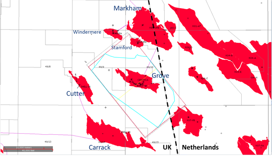
Development Geophysicist for the Grove Field.

 HomeConsultancyAbout Us More

This work was carried out for Centrica who bought the Grove Field as a partly-developed gas field that was thought to be of Permian age. 
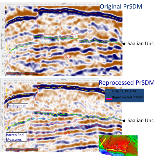
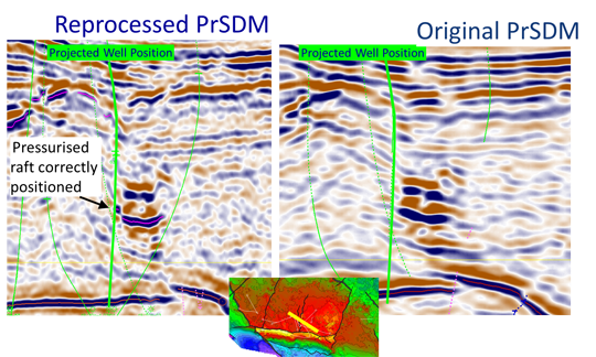
Detailed geophysical analysis proved the reservoir to be Carbonifereous, allowing the three remaing wells to be drilled and completed accurately to give a consistent, producing field in a low permeability reservoir.

The reprocessing of the seismic data, referred to below is covered in the technical paper
Sugrue, M., Goodall, C., Fletcher, S., King, D. and Gasiorowski, T. [2010] Careful Processing Leads to Cheaper Wells: Grove, An SNS Case History, PETEX Conference.

GroveMapMap
Location of the Grove Gas Field in the Southern Gas Basin, close to the UK-Netherlands border

The Grove field lies close to the UK/Dutch border. The gas is exported, via the Markham Field, to Den Helder, in the Netherlands.
Grove Section1
The improvement gained in the imaging of the Saalian Unc and the underlying reservoir section.

Grove Well Correlation
Detailed well ties on the improved seismic data confirming a previously unrecognised sand body.

Following initial detailed well ties it was clear that the reservoir was Carboniferous in age.

This left a task for the 3 remaining development wells. Instead of the planned-for reservoir of 3-4Md permeability and 12%-15% porosity, we were dealing with a challenging reservoir of less than .1 Md permeability and 10%-15% porosities.

The seismic was reprocessed allowing the overlying Saalian Unconformity and the reservoir units to be accurately mapped.

The more accurate reservoir characterization allowed the well planning to be rapidly re-thought through to give a very successful drilling campaign including a well that targeted a sand package found as a result of the new mapping.
Grove Raft
Correct positioning of an over-pressured Platten Dolomite raft

An extra benefit of the improved seismic migration was the better imaging of the Platten Dolomite 'rafts' which float in the Zechstein halite. They represents the original carbonate shelf edge to the salt basin, and in this area, are filled with over-pressured brine and obviously a drilling hazard.

In this example the upper raft had been recognised and proved during drilling.

But it was only on delivery of the new seismic volume, which arrived while the well was being drilled, that the potential hazard of the lower raft was recognised.
The early warning allowed the rig to be prepared for the over pressure, which came in on prognosis.

There were significant drilling time benefits gained through this sharper positioning of the Platten Dolomite.
Back to Project Summary on the Consultancy page Button.png